
VIEW YOUR PROPERTY FROM A NEW PERSPECTIVE
SERVICES

Aerial Mapping
Do you want to see what your property looks like on aerial imagery, but can't find anything recent? Commercial aerial imagery is often outdated; satellite imagery typically has poor resolution. FDMS can collect updated aerial imagery of your property. This can be done once, annually, or multiple times per year depending on your needs.

Timber Harvest Tracking
Are you a property owner that has a timber cut planned and want to be able to capture a before and after? Are you a timber harvester interested in tracking your stands and cuts? FDMS can fly your site before and after, providing aerial imagery and general shots of your harvest.*
*Various factors will influence collection of large areas, such as the number of acres, road access, and weather/wind. Large tracts of land, swamps, etc. provide difficulty for maintaining line of sight with drone equipment and flying time.

Drone Footage
Drones are a great way to get a different perspective of your property, home, camp, etc. Any season is a great time to get aerial shots: In spring, the greens of the trees really pop; summer gives us great sunset backdrops; fall colors provide a great background for a photo print; and winter provides a unique viewpoint with snow on the ground and leaves off the trees.

ABOUT FDMS
Fazer's Drone Mapping Services LLC provides aerial services primarily in Michigan's south central Upper Peninsula and in northeast Wisconsin. FDMS is owned and operated by Nathan Fazer, who resides in Manitowoc County, WI. Nathan's interest in drones has grown over the years from his 15+ years of working in the GIS mapping industry. Nathan is a certified remote pilot, receiving his Part 107 license in 2019. Nathan believes drone collection provides the perfect compliment to GIS and mapping, and is dedicated to capturing useful and updated aerial imagery for landowners, farmers, timber harvesting operators, and others interested in land management.
PROJECTS & EXAMPLES
 Pasture in Fall |  Spring Apple Trees |  Property Aerial |
|---|---|---|
 Winter in the Woods |  Winter Sunset | 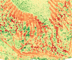 Timber Harvest NDVI |
 Property Aerial in Spring |  Property Aerial in Spring |  Hunting Area Aerial |
 Timber Harvest RGB |  Fall Shot |  Gateway of Trees |
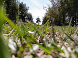 Grass |  Hunting Area Aerial |